You are using an out of date browser. It may not display this or other websites correctly.
You should upgrade or use an alternative browser.
You should upgrade or use an alternative browser.
DIY robot lawn mower
- Thread starter mois25
- Start date
More options
Export threadTwo-Stroke
Lawn Addict
- Joined
- May 7, 2010
- Threads
- 23
- Messages
- 1,594
Two-Stroke, I'm still working with the digital compass because it did keep the Mule
on a straight heading with the reel mower, yes it did waste a lot of energy trying
to turn the reel mowers with its six fixed wheels spring loaded to the ground but
it did work, the electric rotary deck I'm testing now has two casters to maintain
cut hight which can turn any direction with little effort from the Mule which should
require less energy(from the drive system).
I did test the compass as it was set up for the reel mowers, but the electric motors
on the new test deck interfered with it's reading, last night I did get a chance to move
the compass to a new location and should know today if interference is gone.
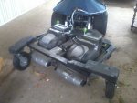
some quick calculations seems to suggest that to cut 4"(off the top) of grass in a 4 acre
field using a 38" electric deck would require close to 300Ah of batteries, while cutting 1" (off the top)
would need 120Ah.
I hope to get a chance to replace the mulching blades with standard blades to see if the
energy requirements change.
Tommy
It's good news if the navigation system is working. It seems to me that getting the mowing units to work should be relatively straightforward -- no great complexity there.
Keep up the good work -- and thanks again for keeping us posted. :thumbsup:
twall, with only four months until this project needs to be completed(self set deadline) I doEverytime I turn around, there's another post in it!
feel the need to keep things moving, not a day goes by without something being done to the Mule.
Two-Stroke, It seems the gene pool is not all that fair for some of us, because for me the nuts & boltsIt seems to me that getting the mowing units to work should be relatively straightforward -- no great complexity there.
of things causes me lots of trouble, I started working on a mowing deck in January yet I'm still working
on it.
I was not able to find a good location for the compass where the electric motors of the mowing deckIt's good news if the navigation system is working.
would not interfere with the sensor(even tried 4' above the mule). While I'm waiting for the navigation
systems secret weapon to get here I'm working on the Yaw sensor.
Tommy
Two-Stroke, the current envisioned navigation system is a collection of senors.It's good news if the navigation system is working.
Yaw senor is just two rotary encoders, one is located at Georges center of turn
and is calibrated in degrees, the other has an 8" wheel that is used as an odometer, the
easiest way to describe it is a Scully.
Digital Compass this is an over the counter, plug&play device that can measure the
earth's magnetic field an allow you to use that information in your computer software.
Gyro this is also a over the counter, plug&play device that is used to stabilize George's
two wheel drive/turns system while pushing snow or mower deck.
Accelerometer this is also a over the counter, plug&play device that is used to stabilize
George while accelerating and decelerating.
GPS this is also a over the counter, plug&play device that allow you to use GPS information
in your computer software.
secret weapon the real secret is if it'l work! last few years we'v been able to buy electronic
pet locators, I think they could be used to correct for GPS position errors.
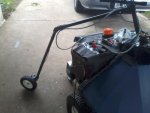
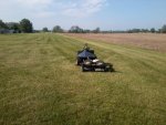
First tests of the Yaw Sensor on sunday products some interesting results, the first test was to
see if the Yaw sensor could keep the Mule tracking straight over the test area with the mower
deck off. and it failed, just because I was there I tested it with the mower running and it did a
sweet job, made it from one end to the other?. seems the tall grass was causing the sensor to
float?, when I tried it with the mower deck off and me pushing down on the sensor it also worked.
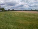
Test area pictured below
Tommy
Attachments
Two-Stroke
Lawn Addict
- Joined
- May 7, 2010
- Threads
- 23
- Messages
- 1,594
Two-Stroke, the current envisioned navigation system is a collection of senors.
Yaw senor is just two rotary encoders, one is located at Georges center of turn
and is calibrated in degrees, the other has an 8" wheel that is used as an odometer, the
easiest way to describe it is a Scully.
Digital Compass this is an over the counter, plug&play device that can measure the
earth's magnetic field an allow you to use that information in your computer software.
Gyro this is also a over the counter, plug&play device that is used to stabilize George's
two wheel drive/turns system while pushing snow or mower deck.
Accelerometer this is also a over the counter, plug&play device that is used to stabilize
George while accelerating and decelerating.
GPS this is also a over the counter, plug&play device that allow you to use GPS information
in your computer software.
secret weapon the real secret is if it'l work! last few years we'v been able to buy electronic
pet locators, I think they could be used to correct for GPS position errors.
First tests of the Yaw Sensor on sunday products some interesting results, the first test was to
see if the Yaw sensor could keep the Mule tracking straight over the test area with the mower
deck off. and it failed, just because I was there I tested it with the mower running and it did a
sweet job, made it from one end to the other?. seems the tall grass was causing the sensor to
float?, when I tried it with the mower deck off and me pushing down on the sensor it also worked.
Test area pictured below
Tommy
Thanks for the detailed update, Tommy.
Since you have so much data to work with from all these sensors, does the decision-making software have to judge the priority given to different (potentially conflicting) pieces of data?
Example: if the GPS thinks all is peachy (on course) but the yaw sensor thinks it has been bumped in another direction, the software has to decide which to believe -- but how?
What does your mom think of this? This is still a project to help her cope with yard work and snow -- correct?
Also, some video of your testing would be fun. :thumbsup:
Two-Stroke, its more timing issues(speed of senors) then prioritizing in the current configuration.Since you have so much data to work with from all these sensors, does the decision-making software have to judge the priority given to different (potentially conflicting) pieces of data?
If the Yaw senor drops in a rabbit hole, the mule well stop and wait(up to 5 seconds) for it's position to be calculated,
the greater the amount of Yawing of George the slower it will go(over 1.5deg it stops).
Update times for senors
Yaw senor 100 times a second
Gyro, Compass, Accelerometer 20 times a second
GPS 1 time a second
Beacons(secret weapon) 5 seconds to get location
I use the Mule(with Joystick) to cut both of our lawns, so she's alway happy to see George, andWhat does your mom think of this?
she's always quick to question his progress.
IMO George has already helped her, she hasn't had to deal with either so far. granted I didThis is still a project to help her cope with yard work and snow
have to do snow by camera(ROV mode) this last winter,and I'm doing the mowing by joystick
still, but it does get it done, so she didn't have to worry about it.
If I can get the navigation system working theres no reason plowing could not be programmed.
As is I used simple hand-tools found in most junk drawers to put this stuff together,some video of your testing
it's not a pretty picture, but can do.
Tommy
Attachments
Last edited:
Two-Stroke
Lawn Addict
- Joined
- May 7, 2010
- Threads
- 23
- Messages
- 1,594
I still can't quite understand how George's controlling software deals with it when input sensors give conflicting information. :ashamed:
It's great that you are getting a lot of use out of George as a remote control mower while still working on his robotic capability.
I know George is very heavy -- probably too heavy to lift -- can you transport him in a trailer or the bed of a truck?
Thanks again for the updates, Tommy.
It's great that you are getting a lot of use out of George as a remote control mower while still working on his robotic capability.
I know George is very heavy -- probably too heavy to lift -- can you transport him in a trailer or the bed of a truck?
Thanks again for the updates, Tommy.
Two-Stroke, each sensor has it's function, and limitations. The absolute positionI still can't quite understand how George's controlling software deals with it when input sensors give conflicting information.
senor is the beacons, but it limited to only four of them, and it takes up to five seconds to get a good
position fix. to over come the four beacon limit the GPS is used, because it can track George to within
20ft it is used to determined which four to use(my house's four beacons or my mom's four beacons).
The Yaw sensor is used to overcome the five second limitation of the beacons, the Yaw sensor can
track the Mule to within ~.1 inch at mowing speed and uses this information in between beacon
updates to help keep george on coarse.
The idea weight for george is 500lb for plowing snow with chains, and mowing with these 10 inch wide turf safe tires.I know George is very heavy
George has been on two road trips(back of pickup truck) so far, both last winter to do modificationscan you transport him in a trailer or the bed of a truck?
that needed a machine shop.
That is kinda funny, I was thinking the same thing.probably too heavy to lift
last fall I was able to pick up one side of george to through a block under him to change a tire,
now I need a floor jack.
Tommy
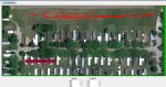
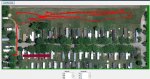
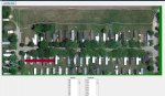
Update:
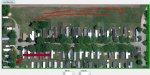
Test Yaw Sensor, but I used the GPS to gage results. I wrote into the Mule's software to record the
GPS data every second and save to a file, then I put together some software to load a map(from Google Earth)
of the test area, then painted on the GPS data(from file).
The Yaw sensor needs to keep the Mule on coarse in between beacon updates(every 5 seconds), so
IMO if it can keep the Mule tracking straight the length of the test area(850ft) it should have no problem
with the ~10ft in between beacon reads.
The first picture is me walking the Mule around the Mowing area as it recorded the values, as a way
to test the GPS values(it did an ok job).
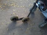
the next picture is the first tested Yaw senor ground contact wheels
then the GPS data(did a very bad job).
the next picture is the second tested Yaw senor ground contact wheels
then the GPS data.
the next picture is the third tested Yaw senor ground contact wheels
then the GPS data(did a very bad job).
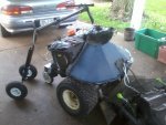
last picture is the Mule in the test area.
Tommy
Test Yaw Sensor, but I used the GPS to gage results. I wrote into the Mule's software to record the
GPS data every second and save to a file, then I put together some software to load a map(from Google Earth)
of the test area, then painted on the GPS data(from file).
The Yaw sensor needs to keep the Mule on coarse in between beacon updates(every 5 seconds), so
IMO if it can keep the Mule tracking straight the length of the test area(850ft) it should have no problem
with the ~10ft in between beacon reads.
The first picture is me walking the Mule around the Mowing area as it recorded the values, as a way
to test the GPS values(it did an ok job).
the next picture is the first tested Yaw senor ground contact wheels
then the GPS data(did a very bad job).
the next picture is the second tested Yaw senor ground contact wheels
then the GPS data.
the next picture is the third tested Yaw senor ground contact wheels
then the GPS data(did a very bad job).
last picture is the Mule in the test area.
Tommy
Attachments
Two-Stroke
Lawn Addict
- Joined
- May 7, 2010
- Threads
- 23
- Messages
- 1,594
I thought you had to transport George between your house and your mother's -- that's why I asked about loading the device. I guess you live close together.
It looks like you've taken on a huge cutting area behind many houses -- are all those people getting some free mowing?
The erratic GPS readings remind me of mountain biking. GPS was a true game-changer in that it gave me greatly expanded navigational capability. I carry a GPS that attempts to record a point every second. Sometimes it gets something nonsensical and is smart enough to throw away the point. Sometimes it gets a point that doesn't differ much from the previous point -- and throws that away. Sometimes it records a bad point or a series of bad points but can't tell they're bad. :laughing:
I can view the points on Google Earth (or Google Maps) after converting the data with a program called GPSBabel. It's interesting to view the data after exploring a new (to me) area.
Thanks for taking the time to post the pictures. It's very interesting to follow this amazing DIY project of yours.